50 FREE San Diego Walking & Driving Tour Maps are instantly accessible below. There are two versions of the San Diego County Map. The Second County Map is an interactive map. Simply scroll your curser over the city you want to tour and it will magically open.
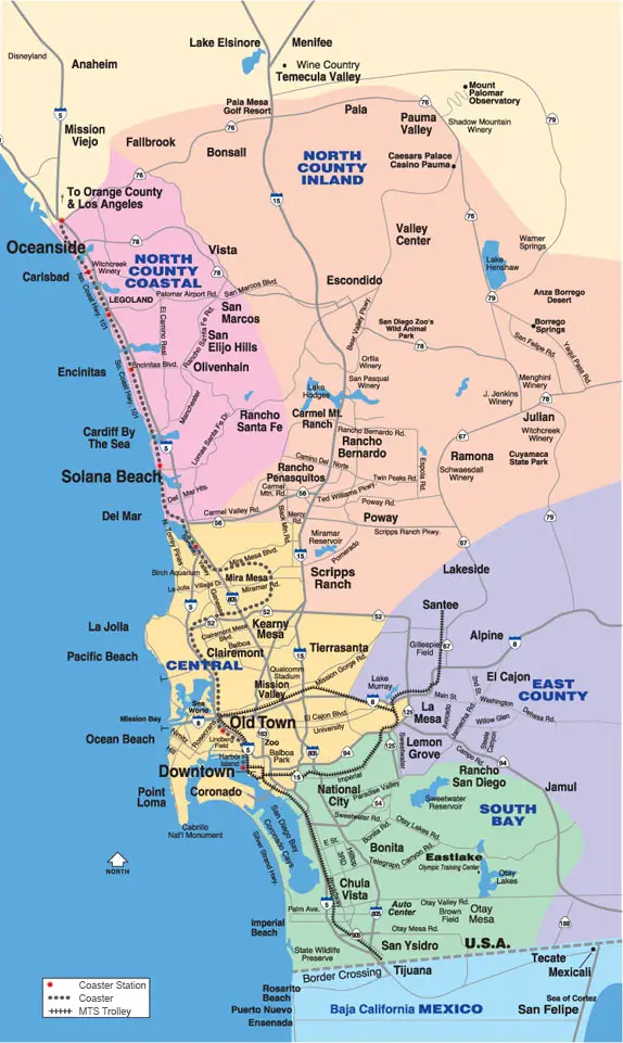
A quick study of the County Map will give you a good understanding of the five-coded color geographical regions of San Diego County. Also of great interest is that the maps shows the layout of the freeway system, and the Red Trolley and Coaster Railroad Lines. Please note that the major freeways run north and south and Highway 8 and lesser freeways run east and west.
Your 50 FREE city tours should begin with a visit to the Cabrillo Monument at the tip of Point Loma. See the Point Loma Chapter below for a map and directions. This historically significant landmark offers both an excellent historical perspective of San Diego’s discovery by the Spanish Explorer Juan Rodriguez Cabrillo, BUT EVEN MORE IMPORTANTLY, SEEING SAN DIEGO MAJESTIC BEAUTY SPRAWLED OUT BEFORE YOU WILL GIVE YOU THE LAY-OF-THE-LAND TO SEE HOW SAN DIEGO IS LAID OUT. Then, San Diego won’t be confusing to you anymore.
After Cabrillo Monument, I’d suggest a tour of the Old Town State Historic Park. It offers FREE parking and FREE admission and is one of the top 3 most visited San Diego attractions enjoyed by residents and visitors alike. Except for the major attractions, practically everything else to do is FREE and my AWESOME chapters, with their essential maps will win the day.
Also, access my DIY How to fall in love with San Diego Tour (hot-linked). It’s specifically written for travelers and newcomers who crave a 1-3 day introduction to the Best of San Diego. Both versions of these 50 FREE Map Tours are excellent. They both represent 54 years of city knowledge combined with custom built maps with map numbers, which correspond to their location in the walking tour. Once you’ve experienced one tour, such as the Old Town Tour, you’ll become an insightful and enriched traveler by not only taking a tour of the historical sites but you’ll also have enjoyed dining in one of my recommended Mexican Restaurants. There, you’ll have enjoyed a frosty margarita and a delicious Mexican meal while being sung to by strolling mariachis. Ole! My tours are the same tours I’d give my best out-of-town friend. So, they are both local and steeped with historical facts.
The numbers on each suburb map correspond to their boldfaced numbers in the walking tour of each chapter.
Hot-Linked to Home page
(1) Click on the Barry Icon at the top left corner of every page to return to the home page, (2) Click on the little box with the arrow in it in the right corner to instantly return to the top of any page. (3) See Today’s most visited pages at the bottom of the home page. Since these hot-linked pages are the most visited pages, they are likely the same pages you are looking for. (4) Content is updated annually.
 Second map is an interactive map. Scroll curser over the city on the Map you are searching for and the city or suburb will magically open.
East County in Purple
East County
Nofth County Inland
North Cty. Inland
Orfilia Winery
Poway
Vista
North County Coastal|Pink on Map
Central San Diego in Yellow
- Balboa Park Map & walking tour
- Bay Park Map and tour
- Convoy St. Asian Rest. Row Map
- Coronado Map & walking tour
- Curbside Takeaways|Deliveries
- Do-it-Yourself Micro-Brewery Tour
- Downtown map & walking tour
- Embarcadero map & walking tour
- Fiesta de Reyes map and walking tour
- Gaslamp map and walking tour
- Hamburgers Top 10 Burger Joints
- Harbor Island
- La Jolla Map and walking tour
Liberty Station /Arts District Map - Little Italy
- Middletown/ Int. Rest. Row & Map
- Mission Bay Map & tour
- Mission Hills
- Mission Valley Map tour
- Ocean Beach Map & walking tour
- Old Town Map and walking tour
- Old Town’s Fiesta de Reyes
- Point Loma/Shelter Island Map & tour
- San Diego Bay from A to Z & Map
- Seaport Village
- Tierrasanta & map
South Bay Maps — Green on Map
Regional Getaways
- Anaheim map——Disneyland Day trip
- Los Angeles map–Only Go if you have to
Temecula map –Wine Growing Region - Scottsdale, Arizona
- Catalina map –Romantic Weekend Getaway
- Mexico
- Tijuana map —–Day trip to Mexico. Ole!
Ensenada map —Mexico’s Seaside Getaway - Mexicali
- Rosarito Beach Map
- San Felipe—–Gulf of Mexico Resort Town
- Valle de Guadalupe Mex. Wine Country
Puerto Nuevo, Mexico Lobster Capitol
Navigate This Website Even Faster Here’s How:
(1) Click here for instant access to 50 suburbs & city walking & driving tours with maps. (2) Click on the Barry Icon at the top left corner of every page to return to the home page. (3) Click on the little box with the arrow in it in the right corner to instantly return to the top of any page. (4) SEE Today’s most visited Pages at Bottom of the Home page.